Posts

Bermuda's Environmental Charter

Bermuda's Environmental Charter ( link pdf )

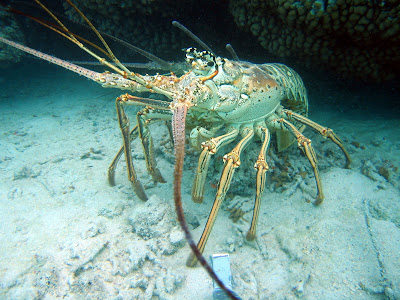
Photo Friday - Big ol' Lobster

Image
A nice big lobster we saw recently on a coral reef survey.

Bermuda Government Announcement - Closure of Blue Striped Grunt Spawning Area

Image
The Department of Environmental Protection within the Ministry of the Environment and Sports has advised the public that an area of North Shore will be closed to all fishing activities between May 1 st , 2009 and June 30 th , 2009 inclusive. The area being closed is a known “fish aggregation area” and is being closed for the conservation and protection of the Blue-striped grunt ( Haemulon sciurus ), and in accordance with the Fisheries Act 1972. The closed area being roughly rectangular in shape is enclosed by a line running in a north-easterly direction from St. Catherine’s Point, St. George’s to the Southern channel marker #12 (32 degrees 23.6 minutes North, 64 degrees 40.1 minutes West) thence by a line running along the southern boundary of the Southern channel to the Southern channel marker #16 (32 degrees 23.9 minutes North, 64 degrees 40.7 minutes West) thence by a line running in a south-westerly direction to a point 32 degrees 23.4 minutes North, 64 degrees 41.4 min...

Extreme Low Tide - updated

Image
The tops of purple sea fans ( Gorgonia ventalina ) were exposed to the air for hours yesterday during flat calm sea conditions and an extremely low spring tide. The beacon at Eastern Blue Cut is in the background. While dramatic, the surprisingly low low tide was a normal spring event. Tide predictions for Sunday show a very low tide was expected [ see link ]. Regardless, the tops of soft corals out on the reef, as well as seagrass meadows across Bermuda (see below), were exposed for hours to bright sunlight and little wind. This will probably result in some mortality and subtle ecological effects that will take some months to restore to normal. The brown substrate in the forground is a subaerially exposed seagrass meadow. This bay pictured above is normally under 3 ft of water, but was exposed during the spring tide at the end of April .

Out doing marine science

Image
Sorry for the lack of posts lately. We have been out working on research projects and doing reef restoration projects. In the photo above - BREAM research assistant Jessie Hallett is transplanting corals at a ship grounding site. We then monitor the corals for survival through time.

From Bermuda News: Turtles survive horrific boat strikes

Turtles survive horrific boat strikes By Amanda Dale Royal Gazette Monday March 30, 2009 Tough turtle: Mark Outerbridge and Patrick Talbot remove barnacles and algae from a boat struck Green Turtle which was found in Jews Bay on Wednesday. The turtle is missing a large portion of shell but is still alive. Photo: Mark Tatem Boat users are being urged to slow down after two more injured turtles were recovered from the water this week.Both Green Turtles are both lucky to be alive, according to Bermuda Aquarium, Museum and Zoo (BAMZ) head aquarist Patrick Talbot. The first was found floating in Jews Bay and the second was recovered from St. George's Harbour."We are amazed they are still alive," said Mr. Talbot.The turtles are now being rehabilitated at BAMZ, but need daily care to clean out their wounds. The first, estimated at between 20 and 30 years old, was spotted by a member of the public on Wednesday in Jews Bay. The turtle was severely injured and Bermuda Turtle Projec...

Mangroves: Back to Bermuda’s Roots

Image
By: Jessie Hallett - BZS Two views across The Lagoon at Ireland Island showing the fringing mangroves and neighbouring seagrass habitats. These natural areas are critical habitat for juvenile snappers and grunts which eventually leave and live as adults out on the coral reefs. While we tend to think of marine habitat restoration as something modern – I have found two instances where healthy mangrove forest were created over decades and centuries ago. During the last few months, I have been comparing extant marine and coastal habitats around Bermuda to those that were present two hundred years ago. I have been doing this by comparing recent aerial photos of the coast and reefs to the same areas charted by Thomas Hurd between 1788 and 1797. Throughout my work, I have been striving to determine what changes have occurred to these habitats, whether the changes have benefited the environment or not, and whether they are natural or anthropogenic. While in many cases, the environmental chan...